How GPS Trackers Work?
Have you ever wondered how your phone knows exactly where you are? Or how delivery drivers find your house in the middle of nowhere? The answer is GPS trackers, and honestly, they’re way less mysterious than you might think. Let’s break down this amazing technology in a way that actually makes sense.
In this article
What Is GPS, Really?
GPS stands for Global Positioning System, and it’s basically a bunch of satellites in space that work together to pinpoint your exact location on Earth. Imagine you’re standing in the middle of a huge field with absolutely no landmarks. You call out, and satellites orbiting above hear your call. By timing how long it takes for your voice to reach them, they figure out where you are. That’s kind of how GPS works, except it uses radio signals instead of sound.
The cool part? This system is free to use. Anybody with a GPS receiver can tap into it. You don’t pay monthly fees or need permission. Your phone has a built-in GPS receiver, and that’s why apps can show you where you are without needing to ask permission every single time.
The Satellites: The Real Heroes
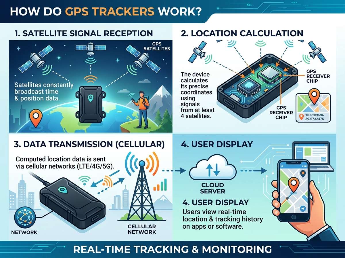
Right now, there are about 24 to 32 satellites zooming around Earth at incredible speeds. They’re positioned so that no matter where you are on the planet, at least four satellites are always visible above you. These satellites are constantly transmitting signals down to Earth, sending information about their location and the exact time.
Here’s where it gets interesting. These satellites have super accurate atomic clocks on board. We’re talking clocks that lose only one second every 300 million years. Why such crazy precision? Because GPS works by measuring time. When a satellite sends a signal, it includes a timestamp. Your GPS receiver picks up that signal and notes what time it received it. The difference between when the signal was sent and when it was received tells you how far away that satellite is.
Think of it like this: light travels incredibly fast, but not instantly. If a signal was sent at 12:00:00.000 and you received it at 12:00:00.067, then that signal traveled for 0.067 seconds. Since radio signals move at the speed of light, you can calculate the distance. One satellite gives you a circle of possible locations. Two satellites narrow it down to two points. Three satellites pinpoint your location on a map. A fourth satellite helps confirm your altitude and removes timing errors.
How Your GPS Receiver Works
Your GPS receiver is pretty straightforward, really. It’s a radio that listens for signals from satellites. When you turn on GPS on your phone, the receiver starts scanning the sky (metaphorically, through the antenna) and tries to lock onto as many satellite signals as possible.
Once it locks onto a signal, it starts the calculation process. Your phone’s GPS chip receives the signal from each satellite, checks the timestamp, calculates the distance, and then figures out where all these distance measurements intersect. The spot where they all overlap? That’s where you are.
The whole process happens incredibly fast. Modern GPS receivers can get a location fix in seconds, though the first time you turn on GPS (called a cold start), it might take a bit longer because the receiver needs to download information about where all the satellites are.
The Magic of Trilateration
Let’s talk about trilateration, which is the fancy word for how GPS pinpoints your location. It sounds complicated, but it’s actually simple stuff.
Imagine you’re at a concert. You hear a bass speaker on one side and a treble speaker on another. By listening to how loud each speaker is, you can figure out roughly where you are in the room relative to them. GPS does something similar, but with distance instead of loudness.
When your GPS receiver gets a signal from a satellite, it knows the distance from that satellite to you. If you draw an imaginary circle around that satellite with you somewhere on it, you’ve got one possible location. Get a signal from a second satellite, and you’ve got another circle. These two circles cross at two points. Add a third satellite, and you’ve narrowed it down to one point. Add a fourth, and you’ve got altitude information too.
That fourth satellite is super important because it helps correct timing errors. Your phone’s clock isn’t as accurate as the atomic clocks in satellites. By getting a fourth signal, your GPS receiver can figure out if its clock is slightly off and make adjustments. This is why your GPS is so incredibly accurate, sometimes pinpointing your location within just a few feet or meters.
Different Types of GPS Trackers
GPS trackers come in many shapes and sizes, each designed for different purposes. Some are super tiny, about the size of a key fob. Others are built into watches, cars, or even collars for pets. Let’s explore the main types you’ll encounter.
Personal GPS Trackers
These are small devices you can carry with you. Parents use them to keep tabs on kids, hikers use them for navigation, and people use them to track their luggage. These devices have a GPS receiver and some kind of communication method to send the location data back to you. Some use cellular networks, others use satellite communication, and some store the data locally and upload it later.
Vehicle GPS Trackers
Your car likely has some form of GPS tracking built in. Modern cars use GPS for navigation systems, and some insurance companies offer GPS tracking to monitor driving habits. Fleet companies use GPS trackers on their vehicles to track deliveries and monitor driver behavior. These trackers send location data to a central server, letting managers see where all their vehicles are in real time.
Smartphone GPS
Your phone has a built-in GPS receiver, which is why you can use maps and navigation apps. Your phone combines GPS data with information from cell towers and Wi-Fi networks to get an even more accurate position. It’s faster at getting a location fix than standalone GPS because it can use cell tower information while waiting for GPS to fully lock on.
Smartwatch and Wearable GPS
Many smartwatches have GPS built right in. This lets you track your running routes, record your hiking paths, and see exactly where you went. Some smartwatches use your phone’s GPS, while others have their own chip.
Pet GPS Trackers
Pet owners use small GPS trackers attached to collars to keep track of their furry friends. These devices work just like other trackers but are designed to be light and durable enough for active pets.
Advanced Tracking Systems
High-end GPS trackers combine multiple technologies. They might use GPS, cellular networks, Wi-Fi positioning, and even Bluetooth to figure out your location. By combining these methods, they can get faster location fixes and work indoors where GPS struggles.
Why GPS Sometimes Fails
GPS is amazing, but it’s not perfect. Several things can mess with your GPS accuracy and speed.
Blocked Signals
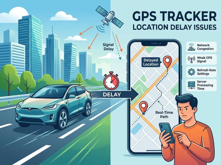
GPS signals are radio waves that don’t easily go through solid objects. When you’re indoors, especially inside buildings with thick walls, GPS has a really hard time. This is why indoor navigation apps use Wi-Fi and Bluetooth instead. If you’re in a canyon surrounded by tall buildings, the signals can bounce off the buildings and confuse your receiver. This is called multipath interference.
Weather Conditions
Heavy rain and snow can weaken GPS signals. Thick clouds usually don’t affect GPS much, but certain types of atmospheric conditions can slow down signal propagation. Thunderstorms create electrical interference that can disrupt signals.
Poor Satellite Geometry
Remember how we said you need at least four satellites for accurate tracking? Well, sometimes satellites aren’t in the best positions. If all the visible satellites are clustered on one side of the sky, your receiver has a harder time calculating your position accurately. When satellites are spread out nicely overhead, your position is much more accurate.
Clock Drift
Although less common in modern devices, sometimes the receiver’s clock can drift slightly. This is why that fourth satellite signal is so important—it helps correct these errors.
Improving GPS Accuracy
Engineers have developed several methods to make GPS more accurate and faster. These technologies work alongside GPS to create better positioning.
Assisted GPS (A-GPS)
A-GPS uses internet data to speed up the process. Your phone downloads current satellite positions and almanac data through the internet, so the GPS receiver doesn’t have to figure that out on its own. This cuts down the time it takes to get your first location fix dramatically.
DGPS and RTK
Differential GPS uses a ground-based reference station that knows its exact position. It calculates the errors in the GPS signals at that location and broadcasts corrections. Your receiver picks up these corrections and applies them, dramatically increasing accuracy. Real-Time Kinematic GPS goes even further, allowing accuracy down to just a few centimeters.
Multi-Constellation Systems
Modern GPS receivers don’t just use American satellites. They can also receive signals from GLONASS (Russian), Galileo (European), and BeiDou (Chinese) systems. Using satellites from multiple systems means more signals available, especially in tricky locations.
Dead Reckoning
Some advanced trackers combine GPS with motion sensors. When GPS signals are weak or unavailable, the device uses accelerometers and gyroscopes to estimate movement. Once GPS locks back on, it corrects the estimate.
How GPS Data Gets to You
Just having GPS coordinates isn’t useful if you can’t see them. Your tracker needs a way to send that information to your phone or computer.
Cellular Networks
Most modern GPS trackers use cellular networks to transmit location data. Your tracker has a SIM card just like a phone, and it sends your location through cell towers to a server. From there, you access it through an app or website. This method is fast and works almost everywhere, but it uses more battery because cellular communication is power-hungry.
Satellite Communication
Some trackers send data through satellite networks. This is essential for remote areas with no cell coverage, like the ocean or mountains. Satellite communication is slower and more expensive, but it reaches places cell towers can’t.
Bluetooth and Local Networks
Some trackers store data locally and transmit it when they connect to a Bluetooth device, like your phone. Others transmit through Wi-Fi when available. These methods use less power, making them great for devices that need to run for months on batteries.
Hybrid Systems
The best trackers use multiple methods. They might prefer cellular when available, switch to Bluetooth when near your phone, and store data locally as backup. This approach maximizes battery life while ensuring you always have access to your location data.
Real-World Applications
GPS tracking technology powers so many things in modern life. Let’s look at some real-world applications.
Navigation and Mapping
Obvious, right? But GPS changed everything about how we navigate. Instead of printing maps or stopping to ask for directions, we just open our phones and get turn-by-turn directions. Apps like Google Maps, Apple Maps, and countless others rely entirely on GPS.
Delivery Services
When you order something online, the delivery driver’s truck has a GPS tracker. This lets the company track routes in real time, optimize delivery paths, and give you accurate arrival windows. You can track your package because of GPS.
Emergency Services
When you call 911, the dispatcher needs to know where you are. GPS helps emergency services locate people quickly. Some smartphones send GPS data along with emergency calls, helping rescuers find people in distress.
Agriculture
Farmers use GPS trackers on tractors and equipment. This technology enables precision agriculture, where farmers can plant seeds in optimal patterns, apply fertilizer only where needed, and monitor crop health with incredible precision. GPS-guided equipment reduces waste and increases yields.
Maritime and Aviation
Ships and aircraft rely on GPS for navigation. Without it, planes wouldn’t know where they are, and ships couldn’t navigate safely. Aircraft use GPS constantly, and it’s essential for landing safely and avoiding collisions.
Sports and Fitness
Runners, cyclists, and other athletes use GPS watches to track their routes and distances. Apps record your exact path, calculate calories burned, and even let you share your workouts with friends. Competitive sports rely on GPS to ensure courses are measured accurately.
Wildlife Tracking
Scientists attach GPS trackers to animals to understand migration patterns, habitat usage, and population dynamics. This data helps protect endangered species and understand ecosystems better.
The Future of GPS Technology
GPS technology keeps getting better. Here’s what’s coming.
Higher Precision
New satellite systems are launching with improved signals and higher frequency transmissions. Researchers are working on getting accuracy down to centimeters for civilian use.
Faster Fixes
As more satellites from multiple constellations become available, devices will get location fixes even faster and in more difficult environments.
Indoor Positioning
GPS doesn’t work well indoors, so researchers are developing new systems specifically for indoor navigation. These use Wi-Fi, Bluetooth, and other technologies to pinpoint locations inside buildings.
Power Efficiency
Battery life is a constant challenge for trackers. Engineers are designing more efficient GPS receivers and exploring new technologies like passive GPS that consume minimal power.
Integration with IoT
More and more devices will have built-in GPS. From household items to industrial equipment, location data will become embedded in everyday technology.
Privacy and Security
As GPS becomes more ubiquitous, privacy concerns grow. Future systems will likely include better privacy protections and encryption to keep location data secure.
GPS Accuracy: What You Should Know
GPS accuracy varies depending on several factors. Open sky conditions give you accuracy within 5 to 10 meters. In urban areas with tall buildings, accuracy might drop to 10 to 20 meters. Indoors, GPS alone often can’t pinpoint you at all.
Different devices have different accuracy levels. Military GPS receivers can be incredibly accurate, while civilian receivers are more general-purpose. High-end surveying equipment can achieve accuracy within centimeters, but that requires special setup and takes longer.
For most everyday uses, GPS accuracy is more than enough. Navigation apps work fine even if they’re off by 10 meters. Fitness trackers don’t need meter-level precision to track your workout. But applications like surveying, construction, and precision agriculture need much better accuracy, which is why they use specialized systems.
Common Misconceptions About GPS
Let’s clear up some confusion that people have about GPS.
GPS doesn’t drain your battery as much as you think. Modern GPS is pretty efficient. What really drains battery is constant cellular transmission, not GPS itself.
GPS is not the same as location services. Your phone can pinpoint you using cell towers and Wi-Fi even without GPS. Actually, phones often determine location faster this way because gathering GPS signals takes longer.
You don’t need service to use GPS. This surprises people, but you can absolutely use GPS without cellular service. You can download maps offline and navigate using just GPS. The only time you need service is if you’re sending that location data to a server.
GPS doesn’t work because of 5G. Some people worry that new cellular networks interfere with GPS. They don’t. GPS uses completely different frequencies.
Your location is not broadcasted. Your GPS receiver listens to satellites; it doesn’t transmit to them. Your location only gets shared if your device actively sends it to a server.
Privacy Considerations
GPS tracking raises legitimate privacy concerns. Your location is sensitive information. Companies can’t legally track you without permission, but consent is often buried in app terms of service. Always check what location permissions you’re granting and why.
If you’re using GPS trackers, know that whoever controls the server can see your location. Be cautious about which apps have location permissions. Most phones let you see which apps use your location and how often. Review these regularly.
Location data combined with other information can reveal intimate details about your life. Where you live, work, worship, and shop all tell stories. Be mindful about sharing this data.
Conclusion
GPS trackers are incredible technology that’s woven into modern life. They’re based on simple principles—measuring signal travel time from satellites to calculate distance—but the execution is mind-blowingly precise. These systems power navigation, delivery services, emergency response, and countless other applications.
Understanding how GPS works helps you appreciate the technology and use it smarter. You’ll know why GPS struggles indoors, why it sometimes takes a few seconds to lock on, and why having multiple satellites matters.
The beauty of GPS is that it’s been revolutionary while remaining relatively simple. A network of satellites, precise timing, and some clever math combine to pinpoint your location anywhere on Earth. That’s the kind of technology that changes everything.
Whether you’re using GPS to navigate to a new restaurant, tracking a package, monitoring your fitness, or doing something else entirely, you’re benefiting from decades of engineering and innovation. Pretty cool when you think about it. Next time you open your maps app and see that blue dot showing exactly where you are, remember all the incredible technology working behind the scenes to make that happen.

Peterson is an automotive safety enthusiast and product reviewer with a passion for helping drivers stay safe on the road. He researches and tests dash cams, backup cameras, TPMS systems, emergency tools, GPS trackers, and other vehicle safety products to provide honest, practical recommendations. Through CarSafeties.com, Peterson shares in-depth reviews, buying guides, and maintenance tips to help drivers make smarter and safer decisions.